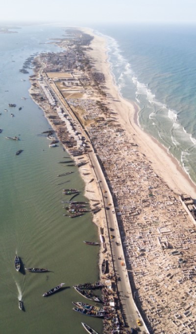
Coastal erosion is a natural phenomenon, further impacted by human factors. In West Africa alone, coastal areas host about one third of the region’s population and generate 56% of its GDP. Among the 54 African states, more than 30 are coastal. This underlies the importance of seaside settlements, especially considering that half of the 15 African megacities (with over 10 million habitants) expected to be developed in the continent by 2050 arise in near-shore areas.
As the African population is predicted to double in the next 30 years, reaching 2.5 billion people on the whole continent, the health and efficiency of near-shore regions is increasingly fundamental to sustain socio-economic practices within coastal zones.
How can we learn more about these coasts and provide policy and decision makers with the tools to better combat future threats and erosion for a sustainable management of coastal areas?
Digital Earth Africa’s latest service release is a monitoring tool that enables users to analyse coastal erosion and growth trends on an annual basis at local, regional and continental scales. Driven by Digital Earth Australia experience, the processing workflow and methods used to build the DE Africa Coastline monitoring service (Coastlines) can be also experienced and tailored in the Sandbox thanks to ‘Digital Earth Africa Coastlines method’ and ‘Coastal Erosion’ notebooks.
Coastal erosion is closely linked to a changing climate, as it is highly responsive to rising sea levels, changing precipitation patterns, and higher temperatures. When combined with the impacts of human development it has the potential to cause significant changes to the coastlines of Africa. Ensuring that the Land, as outlined in Sustainable Development Goal 15, is protected, and restored and that sustainable use is promoted in order to halt degradation and biodiversity loss. Coastlines empowers decision makers to prioritise and evaluate the impacts of local and regional coastal management based on historical coastline change.
 According to the Insight Report - Cost to Coasts; Estimating the benefit of Digital Earth Africa's coastal monitoring service on the continents economy, by mitigating coastal erosion risks in 3 key sectors, Digital Earth Africa could inject $580 million per year into Africa’s economy and change the lives of ~270 million people in three key sectors:
Real Estate & Agriculture
- The rate of coastal erosion represents a vivid threat for African real estate & agriculture, and is putting these sectors at risk in many regions.
- Such a phenomenon has a severe impact on African land, with estimated losses of $7 billion per year.
- DE Africa services can save $90 million of asset value (land & buildings) per year. EO technologies can be implemented in procedures such as:
- Shoreline changes assessment;
- Examination of total water level changes on the coast;
- Forecast and monitoring of sea level with integrated systems;
- Evaluation of maritime security hazards.
Fishery
- The fishing industry serves as a critical source of income and nutrition for millions of Africans.
- Coastal erosion has shown dramatic consequences for the livelihood of fish population, marine ecosystems and local communities, and negatively impacts a wide spectrum of fishery-related areas – e.g., aquaculture complications; infrastructural problems.
- By supervising coastal water quality, mapping distribution of fish, and monitoring water depth, winds and waves, DE Africa could alleviate the loss of marine fish catches by $144 million per year by 2050.
- Assuming that the amount of jobs lost across the industry is proportional to that of fish catches, DE Africa could also help save around 10,000 direct jobs per year over the same period and 20,000 indirect ones – amounting to an extra $131 million of yearly salaries for the latter (direct ones not included to avoid double-counting).
Insurance
- Africa’s non-life insurance penetration rate is 1.8%, about half of the global average set at 3.3%. This opens up opportunities for market expansion.
- Providing decision-makers with actionable information has the potential to increase the efficiency of the insurance industry and create economic value, as data availability is key to avoid market failures.
- By helping insurance companies calculate premiums more effectively and assess claims linked to damages caused by coastal erosion, DE Africa can generate $54 million per year in additional profits for the insurance sector.
- The additional revenues estimated at industry level could also lead to the creation of 4,500 new direct jobs and around 9,000 indirect ones in Africa, resulting in $56 million and $105 million in salaries, respectively.
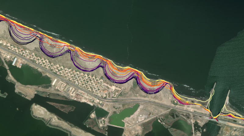
Coastlines is the first of its kind for the African continent, allowing users to observe patterns in coastal change over extended periods by mapping historical data. The service has been developed to support decision-making in diverse infrastructure and livelihood-threatening situations, contributing not only to the Sustainable Development Goals, but also the 2063 agenda of the African Union.
The methods used have been developed, tested, and proven with the operational CEOS Coastline product by Digital Earth Australia and reproduced in the US by NOAA on part of the USA East Coast. The DE Africa team has been working with implementing partners to validate the coastline tool for West Africa initially, with the view to validate at the continental scale. The team validated the tool against reference coastlines generated from very high spatial resolution multi-spectral satellite images. The focus area for the validation has been West Africa, particularly the seaside resort of Saly Portudal in Mbour-Senegal.
The coastlines generated using the notebooks scripts available in the Sandbox were compared with reference data to analyse the coastlines over specific years and study areas, to assess the coastline between specific coordinates. Updates to the DE Africa Coastlines algorithms are in progress to improve the quality of the reference data and enable extraction of coastlines with great precision from the Landsat images.
Explore for yourself
Discover the data on the Digital Earth Africa Map.
Explore the ‘Digital Earth Africa Coastlines method’ and ‘Coastal Erosion’ notebook on the Sandbox.
Learn more about the method and technical details in the Digital Earth Africa Docs.
Do not hesitate to look at our collection of knowledge base articles or ask question in our helpdesk