Coastal erosion is a natural phenomenon. It typically occurs due to a combination of the energy produced by waves, wind and ocean currents. However, a decrease in sediment, increased human activity and global shifts, such as climate change, can enhance and accelerate the effects of coastal erosion. This results in both direct and indirect consequences that affect critical ecological functions in coastal ecosystems.
Users can combine technologies and methods to better understand the coastline. These methods can include; field survey, photo-interpretation, photogrammetry and LiDAR data however some of these technologies are prohibitively expensive and therefore are not always suitable options for accessible coastal monitoring, in particular in developing countries.
Driven by Digital Earth Australia experience, DE Africa has developed tools to help users monitor coastal erosion across the African continent such as the ‘Digital Earth Africa Coastlines method’ and ‘Coastal Erosion’ notebook available on the Sandbox. These take advantage of the long-term monitoring from Landsat images (5, 7, 8 and 9) to build a full view of all of Africa’s coastlines and to accurately assess the coastline where erosion (loss of coastline) or accretion (growing coastline e.g. beaches). Using these tools the Normalized Difference Vegetation Index (NDVI), the Normalized Difference Water Index (NDWI) and the Modified Normalized Difference Water Index (MNDWI) allow users to monitor the dynamics of the coasts across the African continent. These free and accessible tools can overcome cumbersome and expensive conventional methods based on ground surveys.
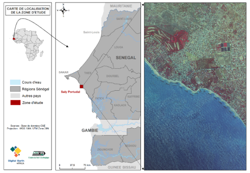
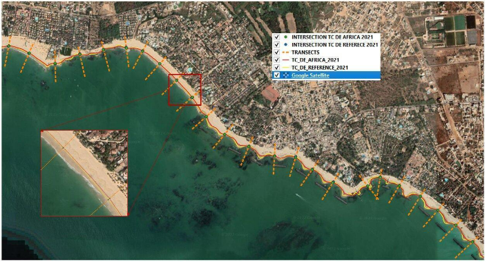
Experts from the Centre de Suivi Écologique (CSE) have been working with the Digital Earth Africa team to validate a tool that enables users to monitor the coastline across the African continent. The focus area for the validation has been West Africa, particularly the seaside resort of Saly Portudal in Mbour-Senegal.
Coastal Erosion on the Senegal Coast
Senegal’s coastline is one of the country's greatest natural, economic and cultural resources with invaluable seaside infrastructure, biological resources and assets. The threat of climate change and increasing human activity are already having a visible effect on the coastline, threatening the sustainability of its ecosystems.
The seaside resort of Saly Portudal is located 80 km from Dakar on the Petite Côte. It stretches from the south of the village of Ngaparou to the Hotel les Cocotiers towards Mbour. The coastline is predominantly sandy and made up of narrow beaches (10 to 70m) and low profile hills and topography (INTAC, 2011).
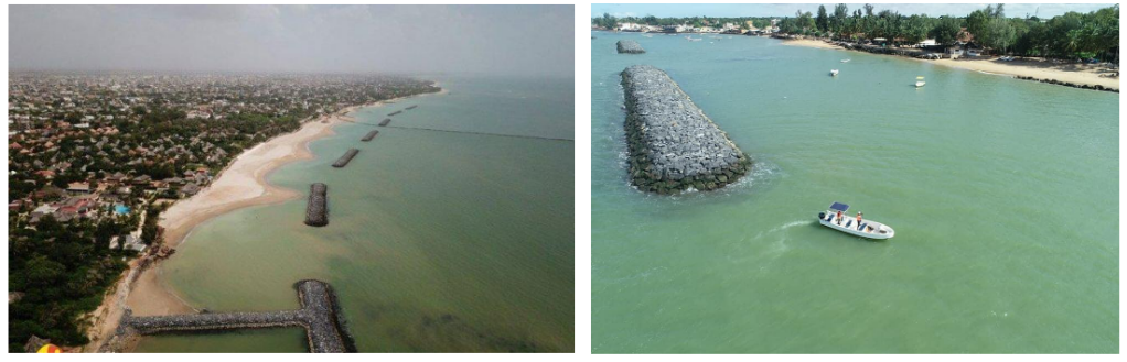
The site is being impacted by unsuitable infrastructure and seafront works, such as breakwaters, which are blocking the natural movement of the water and sediment. Currently the resort records a loss of 1m/year of its coast due to coastal erosion (CSE 2004). Drastic changes are happening within a single human generation along the shoreline, which has retreated from 37 m to more than 280 m between 1946 and 2001 (approximately 0.7 to 5 m per year) (Dabo 2006).
The impacts of the shifting shoreline are already affecting local businesses. For example, The Espadon Hotel was forced to close and the Teranga Hotel lost its entire beach in 2015. Installation of breakwaters was completed in 2020 to prevent further erosion and massive inflows of sand from the open sea. This has helped the tourism, hotels and fishing activity to resume in the area.
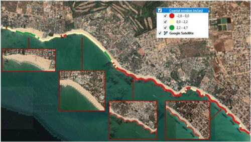
Using tools from DE Africa, the CSE team assessed the coastal erosion along this stretch of coastline. Currently, beach losses are estimated at about 3 m/year on the southern part of the seaside resort of Saly Portudal. The Saly Portudal portion of the coast has experienced strong accretion (beach expansion), benefiting from improved protection, breakwaters and beach replenishment. Other regions are still experiencing impacts from coastal erosion, although the magnitude varies from area to area.
Validation of the DE Africa Coastline Service
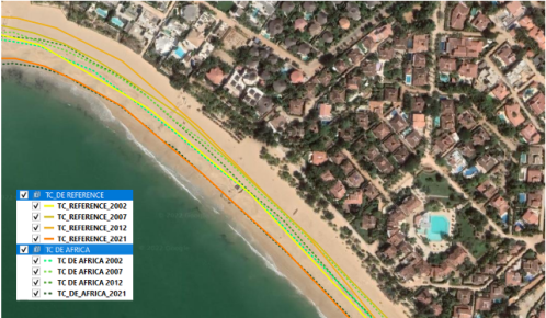
The experts at CSE have been helping the DE Africa team to validate the coastline tool for West Africa. The team validated the tool against reference coastlines generated from very high spatial resolution multi-spectral satellite images. The coastlines generated using the notebooks scripts available in the Sandbox were compared with reference data to analyse the coastlines over specific years and study areas, to assess the coastline between specific coordinates. The accuracy of the coastlines extracted from the Earth observation dataset was statistically analysed against specified performance indicators. The level of precision of the results obtained was between ⅓ and ¼ of a Landsat pixel (30 m) and hence scientifically satisfactory for monitoring coastal erosion at the seaside resort of Saly Portudal and throughout the national territory. Updates to the DE Africa Coastlines algorithms are in progress to improve the quality of the reference data and enable extraction of coastlines with great precision from the Landsat images
What’s next ?
DE Africa continues to develop Coastline tools and services as part of the mission to provide users with reliable and decision-ready land observation data. The DE Africa coastlines service at the continental scale, i.e. covering the whole African continent coastlines, is in development and is currently being validated with the assistance of implementing partners, such as CSE, across Africa to ensure it is fit for purpose for potential users across the entire continent. The service will enable users to analyse coastal erosion and growth trends on an annual basis at both local and continental scales. It will also enable users to observe patterns in coastal change over extended periods by mapping historical data and regularly updated data as it is acquired. The service will support decision-making in diverse infrastructure and livelihood-threatening situations and will contribute not only to the Sustainable Development Goals but also the 2063 agenda of the African Union.
Explore the ‘Digital Earth Africa Coastlines method’ and ‘Coastal Erosion’ notebook on the Sandbox.
Meet the authors
 Ndeye Fatou SANE is an expert in the field of carbon sequestration in forest ecosystems. She has previously worked at the National Research Institute INRA ) in Nancy (France) and the Haute Provence Observatory (OHP France). Currently, she works at the Center for Ecological Monitoring (CSE) as an assistant science and data specialist in the project “Monitoring coasts of West Africa using DE Africa’s Coastline tool.”
 Lissong DIOP is a geologist engineer with expertise in materials study. She has previously worked with geotechnical companies, namely Eiffage Senegal and Fondasol Senegal, in the context of the recovery of mining waste into construction materials. Currently, she is collaborating with the Center for Ecological Monitoring (CSE) as a research engineer in the project "Monitoring the dynamics of the coasts of East Africa". 'West using DE Africa's Coastline tool'.
 Mamadou Lamine NDIAYE is an expert in Earth Observation and GIS. With over 10 years' experience in the use of geomatics tools in areas of land use, coastline dynamics, coastal and urban risks, Mr. Ndiaye is currently project manager at the Center for Ecological Monitoring (CSE). He contributed to the development of the Assessment of West African Coasts, which involves 12 countries of the sub-region (Mauritania to Benin, plus Sao Tomé and Principe).
 Amadou SALL has almost 20 years of experience in sustainable development, land governance and natural resource management. He is currently the head of the Natural Resource Management and Food Security Program of the Centre de Suivi Ecologique (Ecological Monitoring Center - CSE) in Senegal.
M. SALL obtained a master’s degree in Geography (UCAD, Senega) , a certificate in GIS & remote sensing (EPFL, Switzerland) and later with DESS in Decentralisation and Regional Planning (National School of Applied Economics, Senegal). In 2010, he obtained a master degree in Integrated Water Resource Management (IWRM) in Burkina Faso.
Dr. Moussa SALL is a coastal management specialist & focal point MOLOA and WACA in CSE.
References
CSE, 2004. SAPCO-Study of the phenomenon of coastal erosion in the area of Saly Portudal.
Dabo, B. 2006. Coastal erosion in Senegal: the example of Mbour. Postgraduate Doctoral Thesis in Geosciences. Cheikh Anta Diop University of Dakar.
INTAC, 2011. Project for integrating climate change adaptation into sustainable development in Senegal – INTAC. Study report.
UEMOA, 2021. Assessment of West African coasts.