Digital Earth Africa’s Mean NDVI and Anomalies service provides a monthly estimate of vegetation health, and how this compares to the long-term average conditions. This is determined by measuring how different the vegetation health is each month compared to the long-term mean for that month, measured in standard deviations. The service is designed to give users insight into how much the current vegetation conditions have changed relative to historic conditions. It can show improvement, maintenance or deterioration of the vegetation at each 30 x 30 m pixel across the continent. The long-term baseline condition is measured based on the period from 1984 to 2020 and is available through the NDVI Climatology layer.
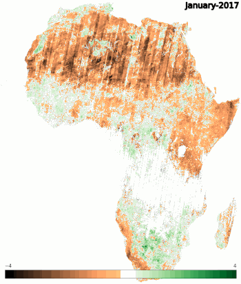
If the NDVI anomaly is positive this indicates that the vegetation is greener than the average conditions, usually suggesting an increased rainfall in a region. A negative anomaly indicates that the vegetation may be stressed due to drier conditions. The anomaly can also indicate the extent, intensity, and impact of drought conditions when compared to the long-term mean. An abrupt and significant negative anomaly can occur following a fire. Examining the anomaly against the NDVI Climatology can confirm the impact of weather, such as rainfall patterns, on the areas observed.
The mean NDVI and the anomalies are generated using all available cloud-free observations from the Landsat 8 and Landsat 9 (from September 2022), and Sentinel-2 satellites. This service provides data monthly from January 2017 onwards at a spatial resolution of 30 m. For more information and product details you can visit Digital Earth Africa docs.
You can explore the service on the DE Africa interactive mapping platform here.
There is also a Jupyter Notebook available on the Digital Earth Africa Sandbox, which demonstrates how to load and utilise the NDVI Mean and Anomalies service for detailed analysis for each month and region, comparisons of conditions observed in previous years and creation of visualisations of the mean NDVI and standardised anomalies.
This service is accessible through OGC Web Service, for analysis in Digital Earth Africa Sandbox and for direct download from the explorer page.
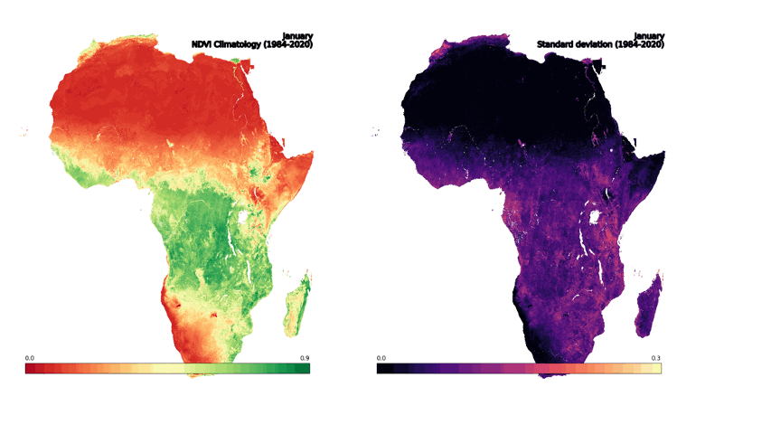
Normalised Difference Vegetation Index (NDVI) Climatology
Digital Earth Africa’s NDVI Climatology product represents the long-term baseline condition across the entire African continent using the full archive of Landsat satellite observations. This provides the baseline for the calculation of the NDVI anomalies component of the Mean NDVI and Anomalies service.
NDVI climatologies are available for each month at a spatial resolution of 30 m and are based on vegetation conditions measured over the period from 1984 to 2020. NDVI climatologies were developed using harmonised Landsat 5, 7, and 8 satellite imagery.
A Jupyter Notebook which demonstrates loading and using the NDVI Climatology product in the Digital Earth Africa Sandbox is also available.
For more information and product details you can visit Digital Earth Africa docs.