At Digital Earth Africa (DE Africa) we enjoy celebrating the amazing women in science that are using DE Africa tools and services to enable change and solve problems with data across Africa. We spoke to Khairiya Mudrik Masoud about her experience in the Earth observation industry, her research on mangrove monitoring in Zanzibar and what she sees as the challenges and opportunities facing women in science across Africa.
Why is Earth observation data important for Africa?
“Fundamental to any solution is good and reliable data” says Khairiya. “The best way to solve global problems is through the acquisition of good and quality data, an opportunity DE Africa provides”. As a Geoinformatics expert, Khairiya considers Geoinformatics an essential science with the potential to minimize impacts of climate change. Reliable and consistent satellite data provides the scale of information that can assist sound decision making across the large areas climate change is affecting. Geoinformatics provides a number of tools that, when applied, can provide the information necessary for decision makers to adapt and combat the impacts. For example, using spatial data and modelling enables flood modelling to inform preventative, adaptive and disaster planning within countries across Africa.
How can we protect critical ecosystems within Africa with data?
The ready-made data and algorithms available on the DE Africa interactive mapping platform and access to the huge amount of remote sensing datasets is “a great asset for people across Africa” Khairiya says. The free and open resource inspired Khairiya to monitor the biodiversity and condition of mangroves in Zanzibar.
Mangroves play a critical role in the ecosystem. They provide habitat, and protective breeding grounds for a number of marine organisms and animals, they protect the coastline from storm surges and waves, and provide a large amount of resources to local communities. They are also an important source of absorbing carbon dioxide and storage of blue carbon (carbon dioxide sequestration in the ocean). Mangrove ecosystems themselves are vulnerable to the changing climate but are critical to protecting ecosystems and local communities against the effect of climate change.
Did you know that mangroves can store about two to four times more carbon (6 to 8 Mg CO₂e/ha (tons of CO₂ equivalent per hectare)) than observed in mature tropical forests.
Khairiya’s work used DE Africa’s satellite data to monitor the extent of mangroves in Chwaka Bay from 2014 to 2020. Her research on mangroves, community work and lecturing was featured in the Amazon Web Services (AWS) documentary series ‘Climate Next’ in the episode ‘The Essential Mangrove’. Learn more about how AWS supports DE Africa here.
How important is it for other professionals to see female leadership in science?
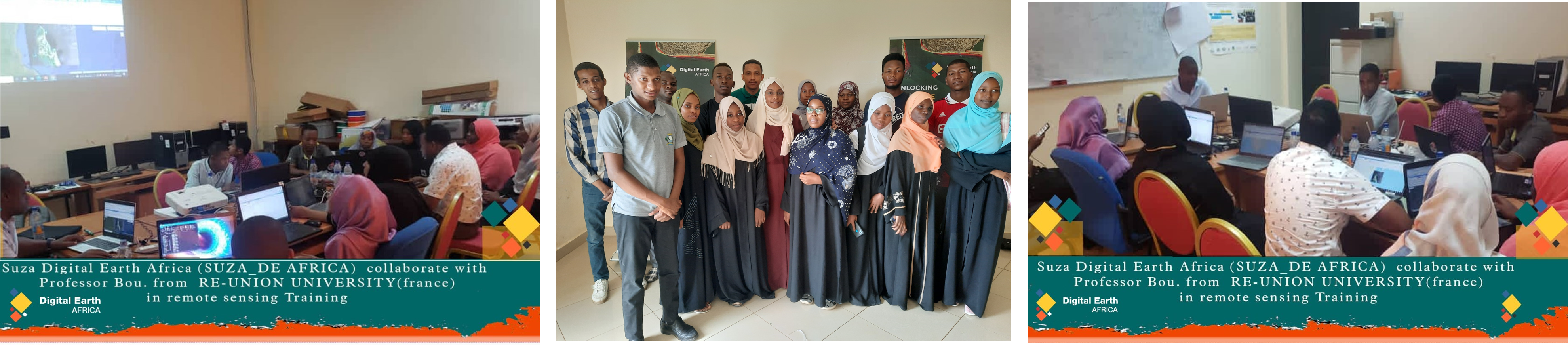
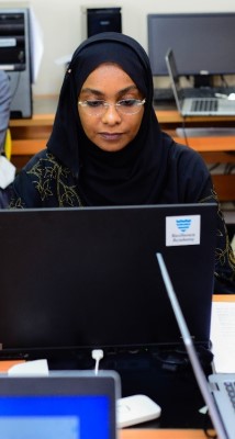
Khairiya is proud, as a woman, to be a leader in her career. She strives to encourage and empower her fellow women, especially the youth, in Geoinformatics as a cutting edge scientific field in Africa. Khairiya oversees the State University of Zanzibar (SUZA) Digital Earth Africa club, a group that equips students with the knowledge and experience to use advanced geospatial tools and Earth observation data using the DE Africa tools and services.
Khairiya sees equipping female students with the skills and experience with digital Geoinformatics tools as important to solving spatial problems in the Zanzibar islands and the broader region. The free and accessible data available on the DE Africa platforms breaks down the barriers for women to utilise the tools, creating a sense of empowerment and equality (an important step to achievement of the SDG 5 of gender equality and empowerment of women and girls.)
“The women can feel included by literally seeing their countries and local areas included as part of the globe” [on the DE Africa interactive map].
“Seeing themselves as part of the world on platforms such as DE Africa helps them feel part of the bigger picture” says Khairiya.
How would you like to see the Digital Earth Africa club progress to empower early career women in science?
In the future, Khairiya would like to extend the Digital Earth Africa club at SUZA into an Earth observation industry training centre for students at other universities in Zanzibar and Tanzania. The centre will aim to help students working with GIS and Remote Sensing technologies to train in the use of the geospatial data and tools of the DE Africa platform and accelerate their work and research. This work is designed to help engage the youth early in their careers with the hope of continuing the skills and use of geospatial data and tools to support spatial solutions to help solve problems in their local society and to inform decision making in government as they enter the workforce.
 About Khairiya
Khairiya Mudrik Masoud is a Geoinformatics expert, MSc. with a Geo-Information Science and Earth Observation and Bachelor of Science with Computer Science. She specializes in Remote Sensing, Machine learning, Image Analysis and Spatial Modeling. She uses Geoinformatic tools to analyse Earth observation data. As an Assistant Lecturer at The State University of Zanzibar, she is an experienced supervisor of Computer Science, IT projects and GIS and Remote Sensing research as well as lecturing, consulting and curriculum development. Khairiya’s passion is in mentoring students through clubs and self-learning to empower the youth.