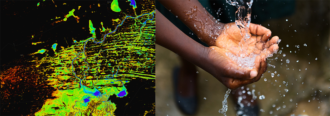
Water is one of the most precious natural resources. It is a fundamental human need for our health and economic stability. As global populations continue to grow and industrial processes increase, so too does our demand for fresh water.
Our first continental-wide service available in the Digital Earth Africa (DE Africa) platform. Water Observations from Space (WOfS), allows anyone to better understand water availability anywhere in Africa. It allows African countries to map, assess and visualise surface water and understand water availability trends over time, including the impacts of floods and droughts.
Why is this Important in Africa ?
The UN 2030 Agenda for Sustainable Development Goals (SDG 6)1 calls on governments and all stakeholders to ensure the availability and sustainable management of water and sanitation for all. This goal goes beyond drinking water, sanitation and hygiene to address the quality and sustainability of water resources.
We support this goal by translating years of satellite imagery into easy to consume information on the presence, location, and recurrence of surface water across the continent.
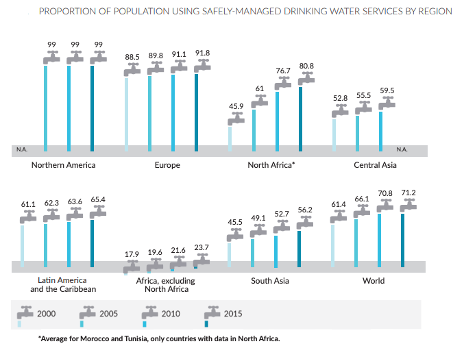
Access to safe drinking water in Africa is generally low by global standards and characterized by wide disparities between and within countries. While official development assistance has continued to increase over time, it has done little to improve the situation. Emerging challenges including climate change, droughts, floods, and water management are major constraints to the access of safe drinking water across the continent. Addressing these challenges requires better governance of water resources, infrastructure investments, access to appropriate technology and policies to improve the management of water scarcity2.
In recent years there has been a major increase in the impact of water related disasters such as floods, causing hundreds of fatalities across Africa, displacing thousands, causing infrastructure and building damage, and threatening food security. The last four decades of archived Earth observation data can provide the information required to map the areas that have been flooded historically, to help predict those that are most likely to be affected in the future, supporting decision makers to plan effectively.
Proportion of Population Using Safely-managed Drinking Water Services by Region (Per Cent of Population)
Water Observations from Space (WOfS)
Water monitoring and management was identified as the first priority area for DE Africa. To address this, we have made a continental scale water monitoring service available, known as Water Observations from Space (WOfS). This service supports nations and stakeholders to make informed decisions, plans, and on-going adjustments that will contribute toward achieving SDG 6 outcomes. It helps users to understand the location and movement of water present in the African landscape. The data allows anyone to identify water resources more efficiently. It helps African farmers and governments use their land and water resources more sustainably, and it enables better planning which increases the availability of safe and drinkable water.
WOfS data supports the sustainable management of water and sanitation for Africa by providing information that enables the monitoring of ecosystems over time. Water information is available through the service in near real-time and can be used for environmental monitoring, flood mapping, monitoring planned water releases, and management of water resources in highly regulated systems. Through identifying trends and changes over time WOfS data can improve the management of water resources, providing a greater understanding of certain impacts, such as floods and droughts.
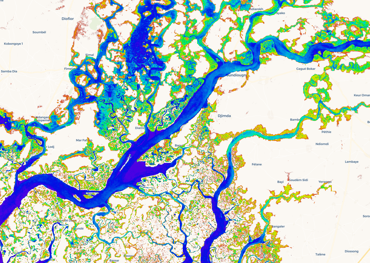
Water Observations from Space all-time summary (WOfS) over Senegal
The data derived from WOfS is available in the DE Africa Map and ESRI’s Africa Geoportal to provide a more accessible view of spatial data in a map-based format. Through data driven mapping, stakeholders and decision makers can more effectively visualise and manage their water resources - dams, wetlands and rivers.
Water Analysis Tools
We are developing a range of additional analysis tools to help our more advanced users address water monitoring and management issues at a regional scale.
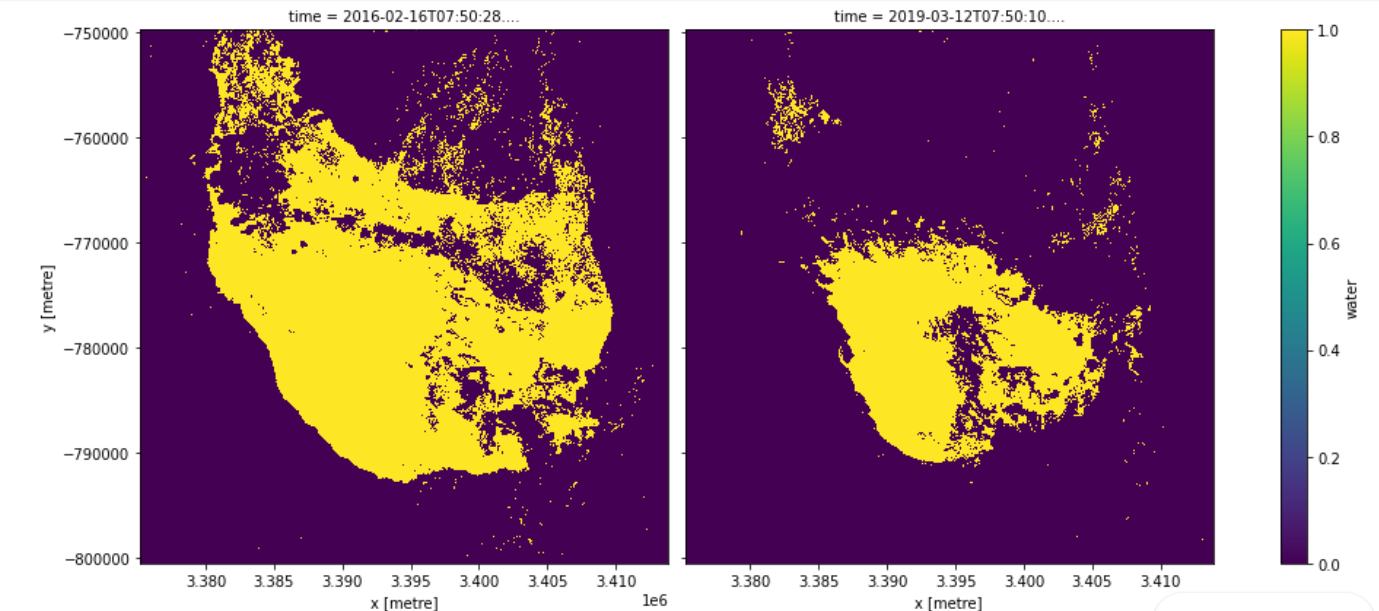
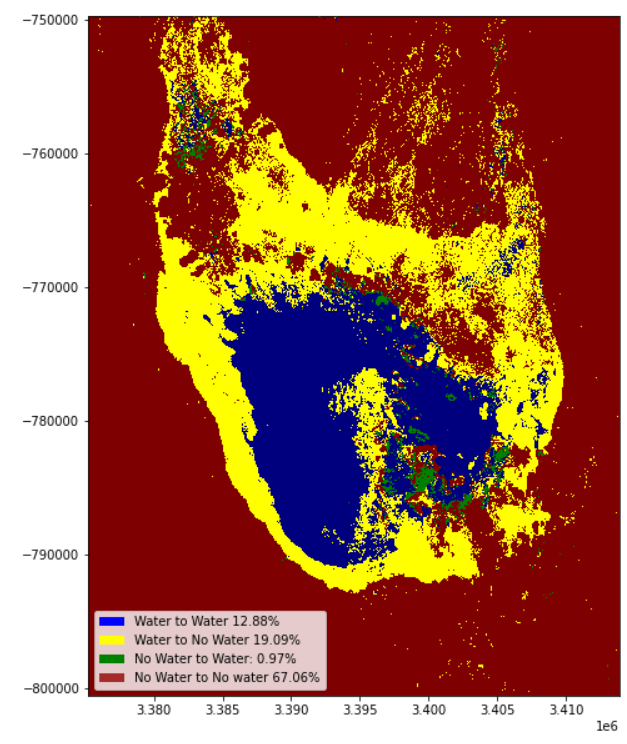
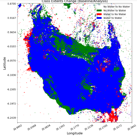
The water extent notebook is an analysis tool that enables users to create their own customised WOfS products, tailored to their specific needs. The example below shows how this tool has been used to highlight changes in the extent of water-related ecosystems over time around Lake Sulunga, in Central Tanzania.
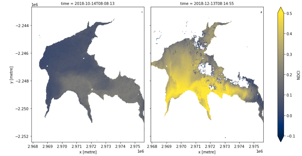
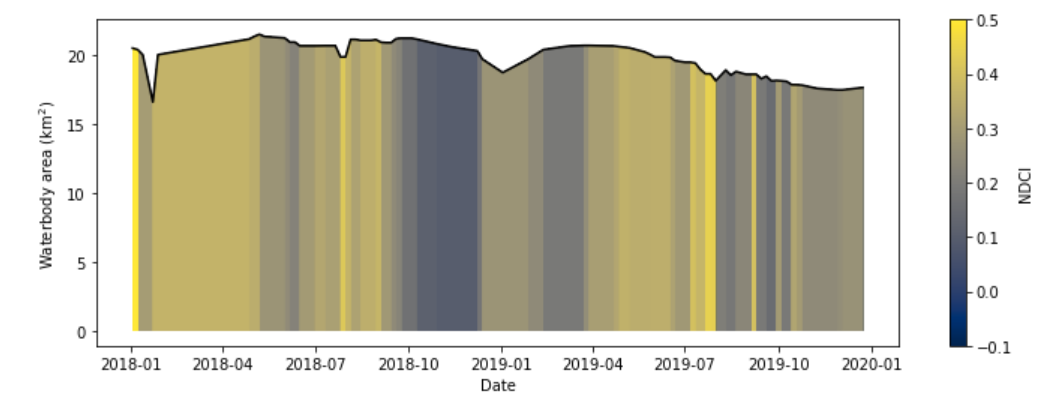
The water quality notebook can be used to detect the presence and distribution of algal blooms in water bodies through time. In the example below, we measure the Normalised Difference chlorophyll-a Index for Lake Bosomtwe, in Ghana, which is affected by pollution. This water quality index, combined with information about the size of the waterbody, is used to build a helpful visualisation of how the water-level and presence of algae in the water changes over time.
Additional potential technical products and services addressing water resource and flooding issues are outlined in DE Africa’s Technical Roadmap, which guides the development of our infrastructure and services.
Data Sources and Validation
Our water services use multi-spectral observations sourced from both the USGS Landsat and European Commission Copernicus Sentinel-2 satellite imagery archives. They are based on a supervised decision tree algorithm that considers surface reflectance measurements in selected spectral bands and a number of normalised difference indices. The algorithm has been developed and well-tested in Australia through the Digital Earth Australia Program.
The primary goal of the data validation strategy within the context of DE Africa is to provide confidence in the data services while also highlighting the limitations – where it works and where it fails – to enable the appropriate application by the end users. Currently, two development versions of WOfS data services are available. They can be used for accuracy assessment and evaluation of the product for different applications.
We are actively working with African partners to assess the accuracy of WOfS data services across Africa’s diverse environment. A validation task team, formed by users and experts from the major centres and organisations in Africa, is supporting the DE Africa establishment team with this effort. Together, we assess accuracy using high resolution imagery that is built into a tool called Collect Earth Online. We work as a distributed team of analysts with regional experts. Each organisation validates the areas they are familiar with, bringing their experience and knowledge of the regional context.
Our team uses the validation process not only to assess the accuracy of the data, but as a vehicle for co-production with end-users. The quantitative accuracy assessment is standard practice, providing statistics of how well a dataset predicts what is actually on the ground, but that in-itself doesn't tell us how useful that data is. For that, our validation team engages with potential end-users in conversations around the dataset of interest. This helps us get a better understanding of how they might use the data and if it meets their needs. This helps us to identify what to improve for the dataset to be useful while also raising awareness of the dataset itself, connecting us with potential end-users before the dataset is even fully launched.
We are excited to explore other methods to co-produce validated data sets with end-users in the future, such as through collecting data on the ground or using citizen science data.
Services, Products and Training
We are committed to provide a suite of services that cover the entire African continent, including analysis-ready datasets and services that translate Earth observation data into meaningful information for users.
There are a number of services all aimed at providing access to DE Africa data:
- The DE Africa Map offers user friendly map-based access to spatial data.
- The DE Africa Sandbox is a cloud-based user computational platform that operates through a Jupyter Lab environment providing users with access to data and analysis tools, democratising access to remote-sensing data to allow for ad-hoc report generation and rapid development of new algorithms.
- The Notebook Repository offers readily available notebooks (user computational workflows and code) to support advanced users to use, interact and engage with the DE Africa Sandbox.
With the help of our stakeholders we have co-designed a free self-paced online training program available on the Learning Platform to support users to work autonomously on the DE Africa platform. The training material includes modules made up of videos and recorded tutorials, manuals with hands-on exercises, live workshops and access to experts to get more help.
Learn more about how the Tanzanian National Bureau of Statistics are using DE Africa services, to gather valuable insights to improve policy to protect Lake Sulunga and the communities who depend on it.
This video demonstration shows users how to use the DE Africa map using the WOfS product, and how to run a sandbox notebook for measuring water extent.
1United Nations General Assembly, 2015 https://www.un.org/ga/search/view_doc.asp?symbol=A/RES/70/1&Lang=E
2Economic Commission for Africa. 2018 Africa Sustainable Development Report. https://repository.uneca.org/handle/10855/24394
3Floodlist, October 2020. http://floodlist.com/africa