Land is the foundation on which communities are built. The UN 2030 Agenda for Sustainable Development Goals (SDG 15) calls on governments and all stakeholders to protect, restore and promote sustainable use of terrestrial ecosystems, sustainably manage forests, combat desertification, and halt and reverse land degradation and biodiversity loss.
Our Digital Earth Africa (DE Africa) platform provides services that can support the achievement of this goal. The platform develops and maintains interactive vegetation and coastline data services based on satellite imagery that offer timely and cost-effective information tailored to land quality and coastline change monitoring.
Why is this Important in Africa ?
In Africa, land degradation and coastal erosion already affects the lives and livelihoods of millions of people. The areas in Africa affected are vast; the aridifying Sahel region stretches from the Atlantic Ocean to the Red Sea, and countries suffering from erosion cover thousands of kilometres of coast.
Land degradation is the persistent reduction of nutrients in soil, often accompanied by loss of biodiversity. Its most extreme case is desertification, where fertile land is reduced to desert1. As one of the driest continents, almost half of Africa is threatened by desertification2. Land degradation in Africa has been driven by extended drought, overcultivation, overgrazing and land clearing for housing. Land degradation is diminishing long-term food production capacity and water availability, creating a vicious cycle.
Coastal erosion is the loss of sediment and bedrock from shorelines, causing receding beaches, cliffs and mangroves. Although this is a natural process, it is exacerbated by human activity, such as infrastructure construction and dune vegetation removal. Coastal erosion has already caused major displacement in West Africa, where shoreline degradation collectively cost local economies up to $3.8 billion. Limiting the effects of coastal erosion, such as the loss of settlements and maritime-oriented jobs, heavily relies on prevention. Actions must holistically consider impacts to the whole coastal ecosystem as solutions considered as ‘hard engineering’ (e.g. such as building a seawall) can have unintended negative effects.
Africa has an ongoing need for well-informed land use policy based on reliable data that can sustainably support population growth and incipient agricultural and urban requirements.
Coastline Analysis Tool
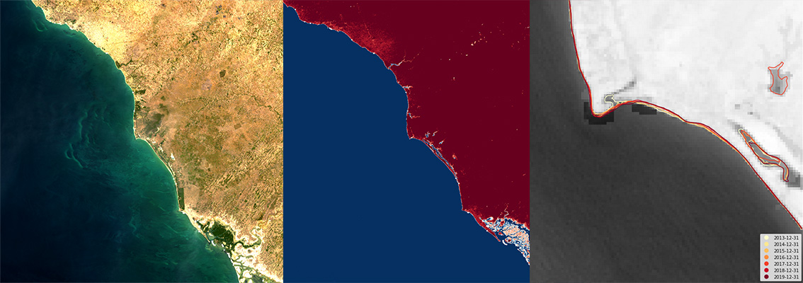
Coastlines available on the DE Africa platform, takes advantage of years of Landsat satellite data to compose extensive images of the African coastline. Conventional methods of monitoring coastline erosion are resource-intensive; field surveys are time-consuming and can be hazardous, aerial photography and LiDAR methods are expensive. Both require frequent revisits to build up a useful dataset. The DE Africa coastline mapping tool offers timely and cost-effective information tailored to land quality and coastline change monitoring. The tool is hosted on the Digital Earth Africa Sandbox, our freely accessible online analytics platform. The tool can be easily used to scope change over time, showing receding shores where erosion has been occurring. This provides insight to the severity of coastal erosion hotspots in an efficient and timely manner. The tool supports analysis of large areas of coast, that can be tailored to different areas around the continent. Coastal erosion contours can then be used in conjunction with ground validation data, or as a basis for further investigation.
An example of the coastal erosion mapping tool over the port of Bargny, Senegal. The contours represent median high tides from 2013 - 2019, where lighter colours represent earlier years and the darker colours most recent. We can see the shoreline has noticeably receded over the last eight years. Note: the analysis has been done with Landsat data, and the basemap used here is from Esri.
Additional potential technical products and services addressing land degradation and coastal erosion issues are outlined in DE Africa’s Technical Roadmap, which guides the development of our infrastructure and services.
Data Sources and Validation
Our land degradation and coastal erosion services currently use multi-spectral observations sourced from the European Commission Copernicus Sentinel-2 satellite imagery archive.
The primary goal of the data validation strategy within the context of DE Africa is to provide confidence in the data services while also highlighting the limitations – where it works and where it fails – in order to enable the appropriate application by the end users. We will be actively working with African partners, such as Centre de Suivi Écologique (CSE), to assess the accuracy of future land degradation and coastal erosion services across the diverse environment of Africa. Learn more here.
Services, Products and Training
We are committed to provide a suite of services that cover the entire African continent, including analysis-ready datasets and services that translate Earth observation data into meaningful information for users.
There are a number of services all aimed at providing access to DE Africa data:
- The DE Africa Map offers user friendly map-based access to spatial data.
- The DE Africa Sandbox is a cloud-based user computational platform that operates through a Jupyter Lab environment providing users with access to data and analysis tools, democratising access to remote-sensing data to allow for ad-hoc report generation and rapid development of new algorithms.
- The Notebook Repository offers readily available notebooks (user computational workflows and code) to support advanced users to use, interact and engage with the DE Africa Sandbox.
With the help of our stakeholders we have co-designed a free self-paced online training program available on the Learning Platform to support users to work autonomously on the DE Africa platform. The training material includes modules made up of videos and recorded tutorials, manuals with hands-on exercises, live workshops and access to experts to get more help.
1World Health Organisation, 2020.
https://www.who.int/globalchange/ecosystems/desert/en/
2Reich, Numben, Almaraz and Eswaran, 2001. Land Resource Stresses and Desertification in Africa.
https://www.nrcs.usda.gov/wps/portal/nrcs/detail/soils/use/?cid=nrcs142p2_054025
3World Bank Group, 2019, THE COST OF COASTAL ZONE DEGRADATION IN WEST AFRICA: BENIN, CÔTE D’IVOIRE, SENEGAL AND TOGO
http://documents1.worldbank.org/curated/en/822421552504665834/pdf/The-Cost-of-Coastal-Zone-Degradation-in-West-Africa-Benin-Cote-dIvoire-Senegal-and-Togo.pdf