Background
The overuse and misuse of pesticides is a serious problem in Kenyan farms, with wide-reaching consequences for human health and the environment. Circumstantial evidence shows that less than 1% of farmers use proper personal protective equipment while applying pesticides - and even fewer carry out cultural practices to reduce or optimize pesticide usage. The issue is exacerbated when farmers' income from agricultural produce increases and farmers reinvest their proceeds in agrochemicals without investing in the corresponding safe use of equipment and practices.
The question is - how might we create high-impact, cost-effective, innovative solutions that address unsustainable agricultural practices in Kenya?
This study focuses specifically on the Lake Naivasha Basin.
Stakeholders cite many reasons why water quality and quantity are both in decline in the basin. Non-sustainable smallholder agricultural practices in upstream areas contribute to the current conservational problems - but are only part of the water problems faced in the Lake Naivasha basin.
Water extent in Lake Naivasha
Digital Earth Africa’s Water Observations from Space (WOfS) product allows users to study the water extent of Lake Naivasha from a spatial resolution of 30 meters.
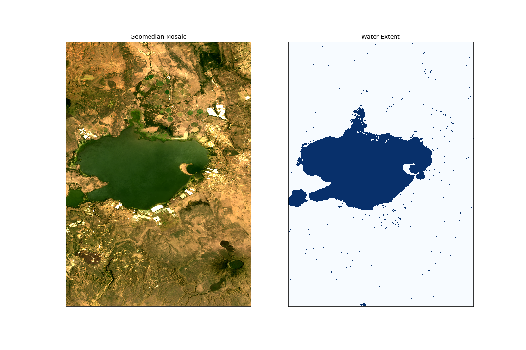 Figure 1: Water Extent using WOfS
WOfS was derived from Landsat 8 satellite observations as part of a provisional Landsat Collection 2 surface reflectance product. The WOfS product shows how many times water was detected in observations. Figure 2 shows the extent of Lake Naivasha over six years - areas coloured in deep blue represent areas where there has been constant water. Areas in red have experienced dry periods - seen particularly in the northeastern shores.
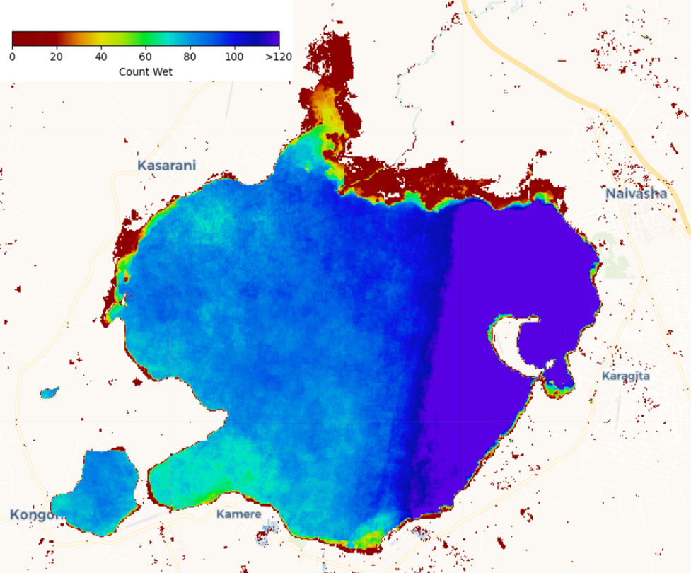 Figure 2: Count of Wet observation generated using WOfS
Using the WOfS service, Joyce Siundu has performed a water quality assessment of Lake Naivasha Basin. She used the Landsat 8 dataset, calculating water quality using a few algorithms:
1. Total Suspended Sediment Algorithms
TSM for Landsat 8:
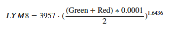
2. Suspended Particulate Model (SPM)
SPM for Landsat 8
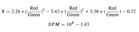
3. Quang Total Suspended Solid
4. Normalized Difference Suspended Sediment Index (NDSSI)
Her findings returned the following results, where black equates to low levels of suspended matter, purple to medium, orange to medium-high and yellow to high levels:
Lake Naivasha water quality (2017-2018)
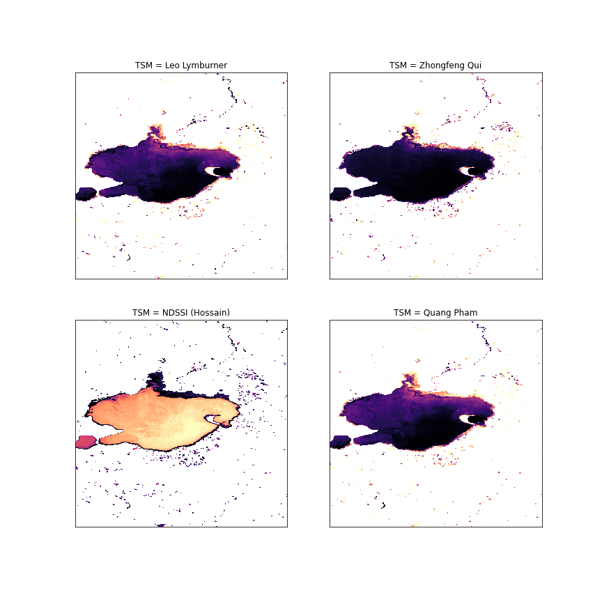 Figure 3: Total Suspended Matter
Joyce also used Digital Earth Africa’s Sentinel 2 GeoMAD to provide Normalised Difference Chlorophyll Index (NDCI) indices (red edge and Red bands) in 2017 and 2020.
In the figure below, the areas shown in red have an NDCI greater than 5 - an indication of water pollution - while areas that are moderate blue have experienced little or no pollution.
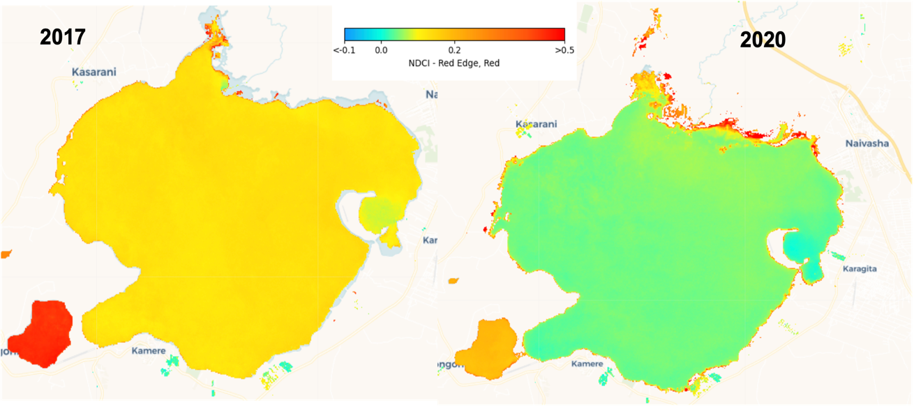 Figure 4: Water quality generated using Normalised Difference Chlorophyll Index (NDCI) index (red edge and Red bands) using Sentinel 2 GeoMAD in 2017 and 2020
Addressing the challenges through the promotion of sustainable agriculture
Lentera Africa has been working with the WWF under the Panda Labs Moon Shoot Challenge, aimed at enabling verifiable positive environmental impact at the local community level. Having identified a need for greater protection against the effects of pesticides, the team has created awareness videos on the effective use of PPEs and the importance of conservation and sustainable agriculture. Lentera has been supplying organic farm inputs to farmers in the Lake Naivasha region which are a substitute for the dangerous chemical fertilizer. This has demonstrated a marked improvement in the crop production of the farmers and reduced discharge of harmful agrochemicals to the environment.
Lentera Africa developed a remote sensing platform and mobile application to enable farmers to improve their productivity as well as transition to more sustainable agriculture. Dubbed CROPHQ, the platform has enabled farmers to get access to hyper-localized weather data, satellite-based crop health maps as well as a record-keeping tool. Lentera is working on incorporating the DE Africa platform into the CROPHQ app for crop health analysis and crop yield estimation based on crop phenology using EVI and NDVI as proxies.
About Joyce Siundu
Joyce Siundu is currently a Solutions Engineer at ESRI Eastern Africa.
Previously she was a GIS/Remote Sensing Analyst at Lentera Africa in collaboration with WWF following their win in Panda Labs Moonshot challenge. Her main area of focus was to address unsustainable Agriculture in the fragile Lake Naivasha basin using Remote Sensing.
Before then she engaged in various projects while at World Agroforestry (ICRAF) such as Tree Cover Change Mapping- Silvopastrol Systems- Colombia (2000-2017) and Soil erosion risk mapping using the RUSLE method
She is a consultant on Carbon Benefits Tool: Modelling, Measurement and Monitoring whose main aim is to provide a cost-effective and end–to–end estimation and support system for showing carbon benefits in Global Environment Facility (GEF) and other natural resource management projects.
Joyce has also worked with the International Center for Humanitarian Affairs (Red Cross) on Flood Impact mapping and prediction using the R shiny dashboard and Health data processing for selected counties in the coastal region.
She took part in the African Women in GIS (AWIGIS) mentorship programme cohort two; a programme that ran for 6-months.
She is passionate about the environment; and often volunteers with Greenpeace Africa.
She holds a bachelor’s degree in applied science in Geoinformatics from The Technical University of Kenya.