Mangroves in Somalia play a vital role in reducing shoreline erosion, and habitats for fish and birds are critical for conserving biological diversity. Somalia has the longest coastline of mainland African countries, approximately 3500 km, with mangrove forests found in some areas along the coast, in the northern and southwestern coastal lines, including the southern part of the Sa’ad ad-Din Islands and the coastal zone close to Djibouti. Somalia has a total mangrove forest coverage of 48 square kilometres, and the extent of Mangrove has decreased by 1.65 square kilometres between 1996 and 2020.
The loss of biodiversity, habitat degradation and the modification of mangrove and coral reef ecosystems along the coastline are among the main environmental concerns in the Horn of Africa Region, especially Somalia. Since 1991, Somalia has been subjected to extreme environmental degradation, natural and artificial. The loss of biodiversity and the degradation of mangrove habitats in Somalia are apparent and visible ecological consequences. These are the consequences of climate change, causing rising sea levels and high sea temperatures leading to coral bleaching combined with the direct human pressures on the coastal and marine environment from increasing coastal populations, pollution and human mismanagement.
Unfortunately, these mangrove habitats are regressing at an alarming rate due to climate change. Coastal erosion, rising sea levels and human activity have contributed to the degradation of mangroves and have led to the loss of suitable fish along the shoreline. UN Sustainable Development Goal (SDG) 14.5 endeavours to conserve these essential coastal and marine areas, and the Somali government has been taking protective measures to help achieve this target.
The Digital Earth Africa Platform allows researchers to access geographic information to study environmental changes. Usually, ground surveys, as preferred by coastal managers, are costly and time-consuming. There is a need to seek alternative methods for ecosystem evaluation for a country such as Somalia. Alternatively, satellite imagery has been used to map such areas, providing a cost-effective way and timely reporting of mapping mangroves over time. Developments in public infrastructure, such as Digital Earth Africa (DE Africa), provide analysis-ready data (ARD) covering over 35 years of Landsat (30 metres) and over seven years of Sentinel 2 (10 metres).
Digital Earth Africa Champion – Liban Hassan
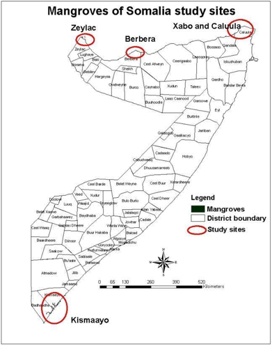
Liban Hassan from Somalia was trained in how to use the DE Africa platform as part of the joint training on Timely Monitoring of Environmental SDG Indicators in Somalia with Earth Observation and Geospatial Tools by the Global Partnership for Sustainable Development Data (GPSDD), DE Africa and Somalia National Bureau of Statistics (SNBS) held in Mogadishu, Somalia in February 2023. Further, Liban is now using DE Africa analysis-ready satellite data to produce a time series for analysis to study mangroves in Somalia, including Berbera, Alula (Caluula in Somali language), Kismayo, Habo (Xabo in Somali) and Zeila (Zeylac in Somali), to inform resilience and protection plans for mangroves in Somalia.
Results of the Mangrove Analysis
The analysis from DE Africa compares with the Global Mangrove Watch (GMW), an initiative that tracks global mangrove extents. In addition, Liban has been able to identify hotspots from 2014 to 2020 as DE Africa classifies mangroves using the Normalized Difference Vegetation Index (NDVI) and Normalized Difference Water Index (NDWI) and shows the extent of mangrove coverage in green. This analysis can highlight areas prone to disasters such as flooding or those that have experienced overexploitation of mangrove resources due to salt production and wood for fires and housing.
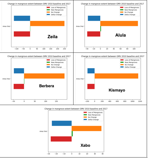
In the five towns: Berbera, Alula (Caluula in Somali language), Kismayo, Habo (Xabo in Somali) and Zeila ( Zeylac in Somali), Liban was able to highlight changes in mangrove areas over the analysis period of 2010 to 2017. The results show the differences in mangroves as seen below, with loss in mangroves shown in red occurring in all towns of Zeila, Berbera, Alula, Kismayo, and Habo and more failures apparent in Zeila, Alula and Habo, indicating areas that have experienced much coastal erosion. Nevertheless, new mangroves are observed in the same period (shown in green) in Alula and Xabo.
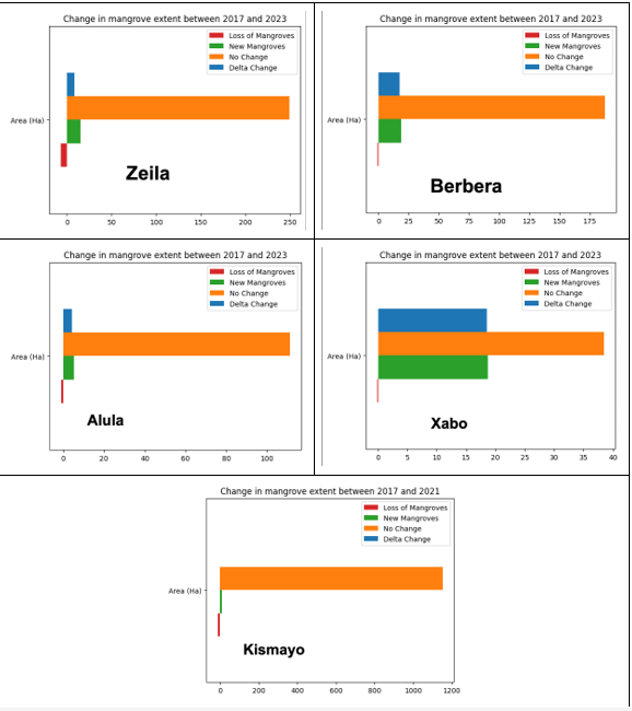
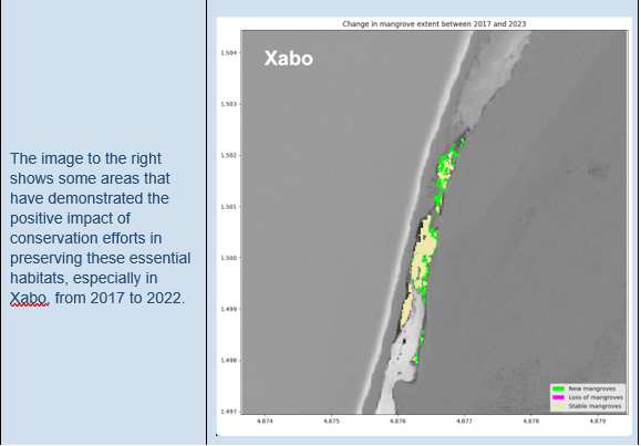
Similarly, making a comparison between the period 2017 to 2022, the results indicate Zeila lost most mangroves (loss of mangroves is shown in red in the diagram below) and restoration of mangroves (new mangroves are shown in green), observed in Xabo (Habo).
Coastline Monitoring
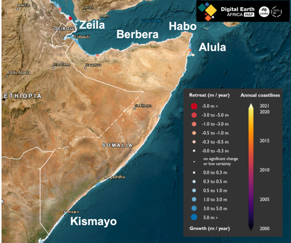
Liban explored the DE Africa Coastline Monitoring Service over Somalia to enhance his analysis further. DE Africa coastlines is a continental dataset that includes annual shorelines and rates of coastal change along the entire African coastline from 2000 to 2021 and shows trends enabling coastal erosion and growth to be examined annually. Liban was able to discover hotspot areas, which correlate with the mangroves analysis as shown on DE Africa Maps coastline service, especially in Zeila (with some areas with over 5 metres of changes in the coastline); please see story map https://maps.digitalearth.africa/#share=s-yBrFOuxlPb8JQVY20S5qoFBrtpb
Conclusion
In conclusion, the timely monitoring of mangroves in Somalia through advanced technology and the Digital Earth Africa platform has provided valuable insights into the state of these critical ecosystems. Mangroves, essential for shoreline erosion reduction and biodiversity conservation, have faced significant challenges due to climate change and human activities.
This analysis has tracked changes in mangrove coverage over time through the dedicated efforts of individuals like Liban Hassan, who utilised DE Africa's analysis-ready satellite data. The results highlight both areas of concern, where mangroves have been lost, and areas of hope, where restoration efforts have shown a positive impact, especially in Xabo.
Moreover, Liban's exploration of the DE Africa Coastline Monitoring Service has revealed correlations between mangrove analysis and coastal changes, further emphasising the importance of preserving these vital habitats. Technology and geospatial tools have enabled us to understand better and address the challenges facing Somalia's mangroves.
In pursuing UN Sustainable Development Goal 14.5, which aims to conserve coastal and marine areas, the work carried out by Liban Hassan and the integration of DE Africa's resources are steps towards a more sustainable future for Somalia's coastal ecosystems. Through continued research, analysis, and conservation efforts, we can strive to protect these essential habitats and ensure a brighter future for our environment.
To read more about Liban Hassan Mohamed, follow this link to a short biography and information about his background.
Would you like to be featured as a DE Africa Champion? Submit a use case to the DE Africa Team.
CONNECT WITH US
Website: https://www.digitalearthafrica.org
Email: info@digitalearthafrica.org
Enroll for our free learning courses: https://learn.digitalearthafrica.org.
Follow us on social media: Digital Earth Africa (@DEarthAfrica) on Twitter and Digital Earth Africa | LinkedIn via LinkedIn.
References
UNEP, 2005a, Caribbean Environment Outlook. UNEP, Nairobi, Kenya Arthurton R, Korateng K 2000. Coastal and Marine Environments. ENVIRONMENTAL STATE-AND-TRENDS: 20-YEAR RETROSPECTIVE. NOAA UNEP/GPA 2003. Review of National Legislations related to Coastal Zone Management in the English-Speaking Caribbean. WIOMSA 2005. Understanding socio-economic changes in coastal communities. New Socio-Economic Monitoring Network in the Western Indian Ocean. WIOMSA News brief. UNEP 2006. Africa Environment Outlook2. United Nations Environment Programme, Nairobi Kenya. DAVID Obura D and Abdulla A, 2004. Assessment of Tsunami Impacts on the Marine Environment of the Seychelles. CORDIO East Africa, P.O.BOX 10135, Mombasa 80101, Kenya and IUCN Global Marine Programme, Parque Tecnologico de Andalucia, Calle Marie Curie, 35, Malaga Spain
Mumuli, S. O, Alim, M. and Oduori, G., 2010. Monitoring of Mangroves in Somalia (Puntland, Somaliland and South Central Somalia). FAO-SWALIM. Project Report No. L-19. Nairobi, Kenya