Consistent access to sufficient food is one of the biggest challenges facing the African continent. 33.8 million people are living with acute food insecurity in East Africa alone, and a growing population paired with decreasing food production mean predictions are that Africa will be fulfilling only 13% of required food production by 2050. According to a technical report by the UN Environment Program it is expected that growing seasons will be shortened as optimal growing temperatures are more often exceeded in a changing climate. The ongoing pressures of the pandemic are only making agricultural yield even more unpredictable.
Urgent, data-driven action is required to address the issue effectively. Earth observation will be a key contributor as policymakers and industry players seek to make a difference by better understanding crop growth cycles, optimising water management practices and using pesticides effectively. It has been demonstrated in India that understanding the ideal sowing date of wheat can be anticipated by EO data. By optimising sowing dates it is estimated that wheat production could be raised by 10% annually in Africa.
A recent study by the World Economic Forum stated that ‘through the provision of EO data products for African agriculture, Digital Earth Africa (DE Africa) has the potential to generate an impact of up to $1 billion a year.’
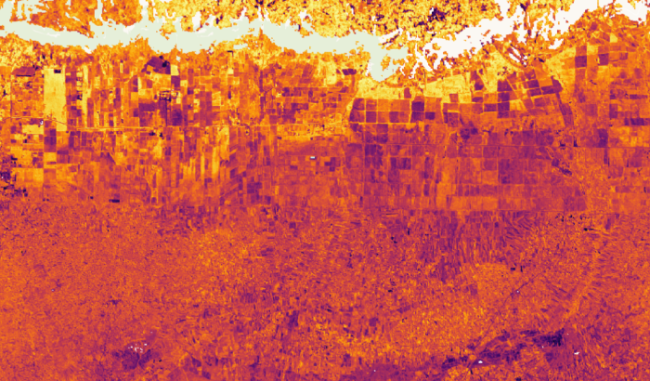
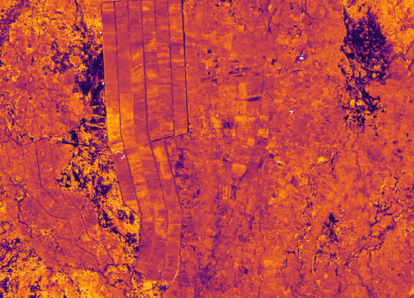
Cropland extent map
"For a region (East Africa) that is constantly faced with food insecurity, the DE Africa crop mask forms the basis for effectively understanding the dynamics of food production by knowing where the crops are, how much there is, and on how these lands ought to be managed," David Ongo, RCMRD.
Digital Earth Africa’s latest service release is a provisional cropland extent map for Northern, Eastern Africa and Western Africa. The service shows the presence or absence of crop for a 10 metre pixel resolution, and is the product of continental-scale collaboration. The data in the cropland extent map service provides a useful base layer for inclusion in models that help to predict continent-wide impacts to agriculture.
The ability to detect the presence of cropland will empower governments to understand their countries’ food supply potential, and to effectively plan food purchasing or supply chains from data-driven insight. Private sector industries, such as insurance agencies, could use the map to understand the patterns from the past and can help predict risk for their customers.
This data will help even non-technical users to understand the spatial footprint of crop growth across Africa, accurately demarcating areas of farmland that have been sowed and harvested at least once in a year. Unlike other continents, Africa does not have a great deal of large scale agriculture, instead trending towards smaller cultivation areas. Therefore it is much harder to observe and predict cropland extent. This new service has a broader coverage focusing on consistent quality for all countries and is a step towards reaching a continental scale product.
Based on an independent validation dataset, DE Africa's cropland extent map has an overall accuracy of 90.3 % for East Africa, 83.6% for West Africa, 94% for North Africa and includes a per-pixel classified layer, per-pixel crop probability layer, and an object-filtered (with image segmentation) classification layer. The cropland extent maps were built separately using extensive training data from East and West Africa, coupled with a Random Forest machine learning model. Learn more about the methods used to produce the cropland extent map here.
The cropland extent map has been designed and validated in collaboration with a distributed group of institutions across Africa including RCMRD (Kenya), OSS (Tunisia), AfriGIST (Nigeria), AGRHYMET (Niger) and NADMO (Ghana). This release includes coverage for Eastern and Western Africa. For Eastern Africa the location of croplands in 2019 cover Tanzania, Kenya, Uganda, Ethiopia, Rwanda, and Burundi. For Western Africa the location of croplands in 2019 cover Nigeria, Benin, Togo, Ghana, Cote d’lvoire, Liberia, Sierra Leone, Guinea and Guinea-Bissau. For Northern Africa the location of croplands in 2019 cover Morocco, Algeria, Tunisia, Libya, and Egypt. A similar service for the rest of the African continent is in development.
Explore for yourself
Discover the data on the Digital Earth Africa Map
Sign up to explore the data more using the Digital Earth Africa Sandbox
Learn more about the method and technical details in the Digital Earth Africa Docs