Over the last two decades, climate change and sectoral climate impacts have adversely affected people in Africa and consequently have seen West Africa experience adverse effects on food production due to scarcity in rainfall, water bodies and land degradation. In addition, this has led to human conflict in Burkina Faso as communities vie for limited pasture and water. According to estimates by the Ministry of Animal Resources, around 4,000 disputes between farmers and herders took place in Burkina Faso between 2005 and 2011, resulting in several dozen deaths, and the number increases every year.
The Digital Earth Africa Platform provides the Water Observations from Space (WOfS) tool, which provides a means to monitor water bodies across the continent. The platform empowers countries to access over 35 years of analysis-ready data (ARD) to respond to climate change. WOfS can be used to monitor water bodies in Burkina Faso and support agencies and government ministries to manage anthropogenic pressure on the country’s scarce water resources.
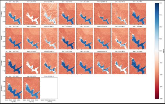
Rodrigue FOTIE LELE, a PhD student from Burkina Faso, uses WOfS as part of his studies to monitor dam water resources for safety and sustainability. Rodrigue used the Modified Normalized Difference Water Index (MNDWI) in Sentinel 2 (10-metre resolution) from 2017 to 2023 and got insights into water changes over a six-year period, which helps update water management plans for Burkina Faso. In the example below, Rodrigue monitors the changes of the Kompienga hydroelectric dam.
The results show that the greatest water extent was recorded in September and decreased to its lowest level in June. The Kompienga dam, however, has an exception in the month of May 2023 where the expected decrease does not occur and the dam does not reach its lowest level in June as shown below.
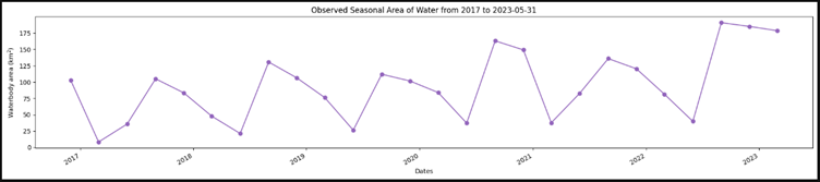
Figure 1. Observed seasonal area of surface water in Kompienga Dam from january 2017 to june 2023.
Further assessment in change in water extent by area for Kompienga hydroelectric dam shows that an area of 102,59 km2 of permanent water surface for 75,85 km2 of area newly occupied by water as shown below.
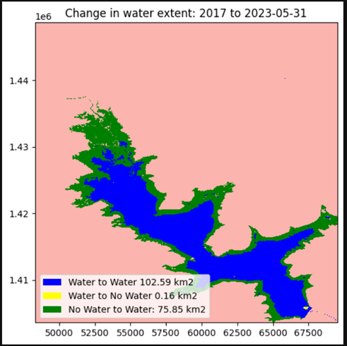
Figure 1. Change in water extent by area in Kompienga Dam from January 2017 to June 2023 (The new surface water covers as increased for more than 73% of its all-time water surface).
From analyzing these data, Rodrigue concludes that the water extent of the Kompienga dam is increasing at a speed that may lead to a dam breakdown which can cause catastrophic flooding. Using this information, he can warn the Burkina Faso authorities to take urgent action before the peak of the rainy season in September. Rodrigue continues his studies and has now looked at 23 other dams in Burkina Faso to see dam walls that need urgent attention by policymakers and make the country's water secure.