Combining remote sensing technology with field surveys and local knowledge creates a powerful blend of information to comprehensively analyse patterns of irrigation, and to understand how, when and why harvests are productive in Africa. These insights can in turn be used to inform decisions that help to secure safe and nutritious food for populations across the continent.
We talked to Timon Weitkamp about how he is using the Digital Earth Africa services in his PhD project to explore irrigation hotspots in Mozambique and understand how to inform more effective agriculture in the area.
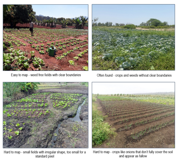
There are a variety of irrigation techniques used in sub-Saharan Africa to enable agriculture in a range of climates. In mountainous areas, techniques include surface irrigation (aka. furrow irrigation), the use of pumps with open water and shallow groundwater sources, cropping in wet valleys or simply hand watering with buckets and watering cans. Capturing the extent of agriculture and observing changes to crops in these areas requires a combination of local knowledge and remote sensing, helping to identify patterns and trends that can inform more sustainable agricultural practices.
Monitoring irrigation with GeoMAD
 Mozambique’s National Agriculture Survey of 2016 showed that 80% of the population is involved in agricultural activities, with 97% of production occurring in 3.2 million subsistence farms. Understanding the extent of irrigated agriculture across Mozambique is important for assessing the resilience of the current systems to the impacts of a changing climate. Using remote sensing, the productivity of existing agriculture can be assessed, which can inform adaptation and mitigation activities to ensure the communities’ food supply and livelihoods remain sustainable into the future.
There are challenges to monitoring smallholder agriculture both remotely and in person. Field surveys are often expensive, time-consuming and difficult to implement over large areas. There are also irrigated areas in Mozambique that are difficult to access - this is where remote sensing becomes an effective monitoring tool. However, remote sensing is not the only answer. Smallholder irrigation in these areas can often be harder to identify from remote sensing imagery alone as they often occur in heterogeneous landscapes among native vegetation. This native vegetation can appear similar to crops and separating cropping from vegetation becomes difficult. The right blend of remote sensing and field surveys can provide a comprehensive picture of the areas in question.
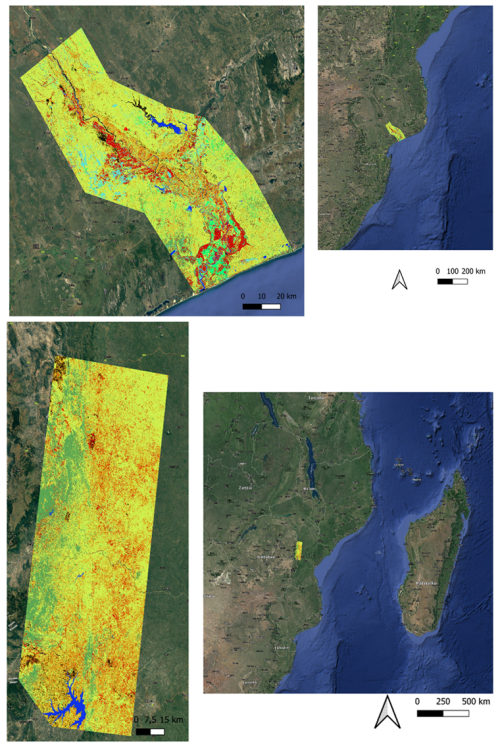
Timon and the team have been using Digital Earth Africa to gather insights into how remote sensing could be used to map irrigated agriculture in the Gaza and Manica regions of Mozambique. They identified irrigation ‘hotspots’ i.e. areas where they are sure irrigated agriculture takes place but are unsure if the exact pixels were correct, highlighting the need for on-ground validation. This kind of information is especially helpful in gaining insights to areas previously unknown to contain irrigated agriculture, which are often the smaller schemes developed and maintained by smallholder farmers themselves.
The team used Sentinel-2 semi-annual GeoMAD in a machine-learned model to map irrigated agriculture. Field observations were used to develop the model. Results were exported into QGIS and visualised as in Figure 2.
Using the DE Africa Sandbox
Timon has been using DE Africa in his research for just over a year. He particularly enjoys using the DE Africa Sandbox including the expansive notebook repository of pre-configured real world examples. The Sandbox is a useful tool because it makes it easier to analyse large areas of satellite images without needing to download data manually, plus the analysis environment and continental data access are available for free. Timon hopes to continue sharing the skills he has learnt whilst using DE Africa tools and services with the National Irrigation Institute of Mozambique (INIR) and will support them to increase their remote sensing capacity.
“I appreciate the support from the DE Africa community - with access to a community Slack channel I can always ask questions and ask for help when I need it,” said Timon.
Scaling and adoption
Based on the initial analysis in this project, the next step is to expand this to decision making entities, such as the INIR and other stakeholders in the future. A workshop was held in March 2022 with INIR to share knowledge of how to make similar maps and continue to develop these methods. Ultimately, the goal is to introduce remote sensing as a complementary tool to their monitoring workflows, providing a cost effective way to monitor larger areas in Mozambique. The information and maps produced in this process can inform decisions such as the distribution of resources to areas under more stress than others, and can provide estimates of the area under irrigation in Mozambique.
Timon and the team chose the Sentinel-2 GeoMAD annual and semi-annual service due to the ease of performing large scale spatial and temporal analysis in Africa. It is easy to use and efficient to run projects of a range of scales. They also like how the DE Africa platform makes collaboration easy for groups as information is easily shared to help communicate the results. Timon hopes to expand the reach of the information he and his team have gathered so far to inform more research and make an impact on decision making with irrigation in Mozambique in the future.
 Timon Weitkamp is a remote sensing analyst at Resilience BV and PhD student at Wageningen University. He works on mapping irrigated agriculture and crop monitoring through remote sensing.