Digital Earth Africa (DE Africa) is excited to announce the commencement of a new project in collaboration with the Food and Agriculture Organisation of the United Nations (the FAO) and Frontier SI.
The purpose of this collaboration is to upscale existing work from the FAO in land cover and crop mapping using DE Africa’s tools, services and experience to expand the impact into more areas across Africa. The aim of the project is for the new systems to be used by National Statistics Offices across Africa and in the FAO’s existing Hand in Hand Initiative.
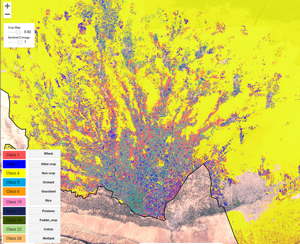
Building on the foundations already established by DE Africa with the Cropland Extent Map service, understanding variables such as the location of cropped areas, crop type, crop extent and crop condition will help users to understand the current state of agriculture and predict the impacts on food security in Africa.
Why Digital Earth Africa?
DE Africa provides data and services that support analysis at a local scale, and is consistently scaling up applications to the continent.
The approach the DE Africa team have taken when building existing tools and services aligns with existing work from the FAO EOSTAT project and will help to build a better understanding of food security in Africa. This includes key factors such as;
- The ability to scale datasets for continental scale analysis.
- The collaboration and co-development of DE Africa tools and services with partners and users in Africa.
- Experience in building capacity in Africa of users in using the Earth observation and geospatial tools and services.
FAO methodologies to be scaled
This project aims to create a prototype for a national system for land cover mapping, which will support the generation of land cover statistics using the existing algorithms developed by the FAO within the EOSTAT project. This land cover mapping capability, developed in DE Africa, will support national reporting on several Sustainable Development Goals. The second part of the project aims to create a prototype for a national system for crop type and yield mapping to support the generation of crop acreage and yield statistics. The project will also build the capacity of local and regional partners in using the new systems as well as DE Africa tools and services.
Using Earth observation (EO) for Food Security
Collaborations such as this are important steps towards ensuring food security across Africa.
To analyze, assess and make informed decisions around food security, decision makers want to know:
- Where do crops grow?
- What types of crops are cultivated?
- What is the cultivated area of each crop?
- What are the growing conditions of crops?
- What is the potential production and the potential yields?
It is also critical that all these factors can be independent of scale; inclusive of national and international circumstances, but also relevant at the local level - even down to individual fields.
This new collaboration aims to combine the expertise, tools, services and methodologies of DE Africa, the FAO and Frontier SI to better understand the food security challenges that are currently impacting Africa and help decision makers to make informed choices in the future.