Preventing just 10% of unregulated mining would be worth $900 million to the African economy (1).
Digital Earth Africa (DE Africa) can be used to provide meaningful insight into changes to the African landscape. This includes mapping and monitoring the vegetation cover, infrastructure changes and rerouting of water sources that are often associated with mining.
The World Economic Forum report “Unlocking the Potential of Earth Observation to address Africa’s critical challenges (1), estimates that unregulated gold mines have caused $9 billion of economic damage a year in Africa.
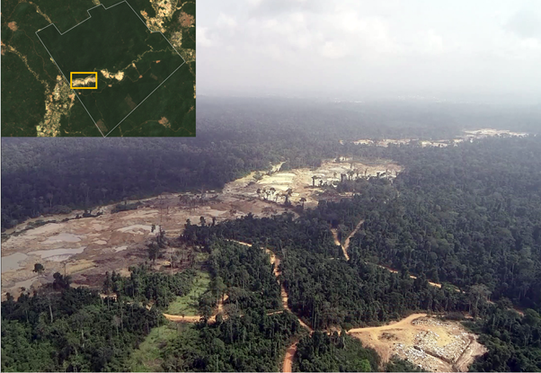
Satellite imagery from multiple time periods, and a range of Earth observation (EO) services, can be used to compare and observe changes in land use. Surface activities such as the creation of artificial ponds (2), land clearing or the building of access roads suggest that mining may be occurring and can indicate that further monitoring may be required (3). EO provides a way for governments and specialists to monitor areas of concern, and DE Africa makes the data these stakeholders need free, open and accessible.
Economic impact
If DE Africa could help to prevent just 10% of unregulated gold mining activity, the estimated economic benefit to the continent could exceed $750 million per year (1). There are significant financial implications of unregistered work, which can cost governments important revenue. It is estimated that unregulated mining activity costs the African continent $7.6 billion in financial losses which could otherwise be used to fund important public interests (1).
Public health
Unregulated mining practices in Africa can have a detrimental impact to public health thanks to higher levels of pollution and poor working conditions. Mining activity consumes a great deal of water, and often waste is discharged into natural basins. This can contaminate the groundwater and cause erosion issues. It has also been shown that water and air pollution can also dramatically exacerbate the spread of diseases - in areas near gold mines for instance, there are much higher incidences of malaria, skin disease and fever with diarrhoea than in areas where mines don’t exist (4). Unregulated worksites also pose risks to those that work there due to a lack of local safety requirements. Mining is a dangerous occupation which poses not only short-term safety risks, but long term effects to the health of workers due to exposure to harmful minerals and conditions underground. Using remote sensing tools to detect mining activities early can enable intervention, preventing these health impacts before they become long-term problems.
Environmental health
There are many ways in which mining activities pose a threat to environmental resources and affect biodiversity. Unregulated mines amplify that threat as they do not comply with environmental requirements and regulations. The impact can be direct - for example, chemical emissions during gold extraction and acids released when some ores are exposed to the air (5). There are also indirect impacts such as the attraction of human populations to mining sites, which can enhance the exploitation of local resources such as food and water, as well as result in habitat loss. While detrimental in their own right, these impacts are compounding existing issues across Africa. Areas are already under resource stress due to a changing climate, resulting in more frequent and longer drier periods, changing patterns of crop growing seasons and more extreme weather events. Reduction in these additional stresses can help to retain the assets of forests and biodiversity.
DE Africa detecting changing landscapes
DE Africa is helping governments and organisations in Ghana detect the impacts of unregulated mining (known as Galamsey) early, helping to mitigate lasting impacts to communities and biodiversity.
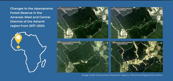
The Apamprama Forest Reserve in central Ghana is a forested area housing a portion of the Ofin river, interspersed with volumes of semi-deciduous trees and medicinal herbs. The reserve also contains rich gold deposits. The reserve represents an important Ghanaian ecosystem and a source of great biodiversity.
Ghana's Environmental Protection Agency (EPA) and Ghana Statistics Service (GSS) wanted to use electro-optical satellite data to better understand the health of the reserve's ecosystem and identify factors that were adversely affecting the environment.
See Detecting Land Degradation Using Geospatial Data (arcgis.com)
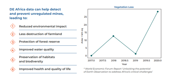
Using the DE Africa Vegetation Change and Detection tools within the Open Data Cube sandbox environment, users are able to measure the presence of vegetation from Landsat imagery and apply a hypothesis test to identify areas of significant change (along with the direction of the change). The Vegetation Change and Detection data analysis tools give greater insight into the dramatic sprawl of land degradation in the reserve, highlighting the rapid increase in potential mining activity between 2017 and 2020.
Using Sentinel 1 radar data (captured every 12 days) from the DE Africa map can assist in early detection of changes on the ground. There is also historical data available with Landsat 5,7 and 8 covering back to the 1980s. This can be used for time series and comparative analysis to detect changes over time. This can help track activities such as land clearing, water management and the growth of settlements.
Learn more about Sentinel 1 data here.
Learn more about our Landsat data here.
Providing free and accessible EO data through DE Africa makes monitoring accessible to a broader range of users removing infrastructure and financial barriers. The goal is to reduce the threats to public and environmental health as well as enhancing the economic benefits of prevention of unregulated activities.
To learn more about the potential value of DE Africa explore our recent activities here.
Explore the data in the Digital Earth Africa Sandbox or Map.
For more information on the data specification, visit Digital Earth Africa Docs.
References
- World Economic Forum’s report “Unlocking the Potential of Earth Observation to address Africa’s critical challenges,
- Daniel M. Franks, David V. Boger, Claire M. Côte, David R. Mulligan (2011), “Sustainable development principles for the disposal of mining and mineral processing wastes”. Available here.
- Pioneers in this domain of innovation were George P. Petropoulos, Panagiotis Partsinevelos and Zinovia Mitraka, who carried out a study in 2012 on multi-temporal change detection scheme based on Landsat TM imagery, useful to identify and analyse the spatio-temporal response of the landscape due to mining activities. Their interpretation model was successful in monitoring the level of surface mining and reclamation in two intensive mining exploration areas of Milos Island in Greece. The limit of their analysis was related to the fact that to quantify the rate of the changes occurred in a monitoring framework, they needed a much higher amount of satellite images acquired at shorter time intervals. Source: Suresh Meregu and Kamal Jain (2013), “Change Detection and Estimation of Illegal Mining using Satellite Images”. Available here.
- Aboka Yaw Emmanuel, Cobbina Samuel Jerry, Doke Adzo Dzigbodi (2018), “Review of Environmental and Health Impacts of Mining in Ghana”. Available here.
- Gold.org, DataHub. Available at: https://www.gold.org/goldhub/data/historical-mine-production