The agricultural sector is a major driver of Kenya’s economy and a source of livelihood for most of the population. The agriculture sector plays a key role in reducing poverty and increasing food security across the continent. The Digital Earth Africa (DE Africa) platform was developed to leverage the capabilities of satellite data by providing open and freely accessible services. Stephen Korir, from Data Driven Agriculture is passionate about providing agricultural solutions using data and technology. Stephen has been using the DE Africa platform to provide an assessment on crop phenology for farms in Eldoret, Kenya. He aims to provide advisory services to small scale farmers and policy makers in support of Kenya’s Big Four Agenda on food security.
While crops are growing, fields may look visually similar. However, health or growth rates from these fields can be quite different, leading to variable and unpredictable revenue. Identifying underperforming crops can have two benefits; the ability to scout for disease damage, and the ability to investigate poor performing fields. Early identification can help farmers to undertake management action such as soil testing or targeted fertilising to improve yield. Satellite imagery can be used to measure plant health over time and identify changes in growth patterns between otherwise similar fields. The Normalised Difference Vegetation Index (NDVI) describes the difference between visible and near-infrared reflectance of vegetation cover. This index estimates the density of green on an area of land and can be used to track the health and growth of crops as they mature. Comparing the NDVI of similar planting areas will help to identify any anomalies in growth patterns.
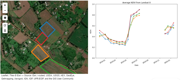
Stephen was able to get an assessment of four different plots (as shown below), and he could easily determine crop health for the four different maize plots. The gap in the plot of NDVI values between July and September could be attributed to the crops being harvested and replanted in September.
Figure 1: Crop health for maize farms in Eldoret, Kenya

DE Africa offers an opportunity to assess differences in agriculture fields over time, location and allow the assessment of vegetation phenology such as planting and harvesting. This can help in validating agricultural policies and make remedies for Kenya to achieve the Big Four Agenda and Sustainable Development Goals (SDGs). Learn more about how higher level crop-based services available on the Digital Earth Africa (DE Africa) platform can assist with managing food insecurity by providing cropland extent maps that map crop health, and crop productivity.